Carson City Outdoor Lifestyle & Tahoe Weekend Fun
February 19, 2026
February 19, 2026
What if your weekend started five minutes from your front door? In Carson City, you can trade traffic for trailheads and plan Tahoe day trips without the long slog. Whether you bike, paddle, ski, or just want easy family walks, you likely want a home base that puts the outdoors first. This guide shows you local trail hubs, water access, ski options, and how to match neighborhoods to your lifestyle, plus smart safety checks for wildfire and flood. Let’s dive in.
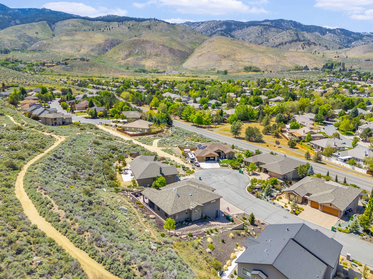
Carson City sits on the eastern edge of the Sierra Nevada, which makes it a low-traffic gateway to Lake Tahoe and the Eastern Sierra. Travel times to Tahoe are often short enough for spontaneous outings, though winter road conditions can add time. The City also invests in parks, trails, and open space, so you get maintained access close to town. You can browse current maps and programs through the city’s Parks, Recreation & Open Space portal.
You have a range of options within minutes of town, from paved multi-use paths to creekside greenbelts and singletrack loops. Many trailheads offer parking and clear signage, so it’s easy to mix short family walks with longer runs or rides.
The Prison Hill and Silver Saddle Ranch area is the backbone of the local non-motorized network. Recent expansions tied together thousands of acres of open space, improving loop choices for walkers, runners, cyclists, and equestrians. For a feel of what’s available, explore the Prison Hill and Silver Saddle Ranch trail system and the city’s Phase II connections celebrated in this Carson River Trail update. Trailheads like 5th Street, Carson River Park, and Silver Saddle Ranch make access straightforward.
For a quick escape with views and spring runoff photos, the Kings Canyon Waterfall is a short, family-friendly hike with options to extend into the larger Kings Canyon system. Get a simple overview and tips from this Kings Canyon Falls guide.
If you prefer a smooth surface or easier grade, the V&T (Virginia & Truckee) alignment offers a paved multi-use corridor near Western Nevada College. It’s popular for family rides and mellow walks. Check current segments and context on the V&T multi-use trail.
Storms can cause seasonal damage and temporary closures. Before you go, scan the city’s Parks, Recreation & Open Space page for the latest notices, maps, and updates. Pack water, respect multi-use etiquette, and yield appropriately on shared paths.
Living near the Carson River means easy greenbelt walks and practical put-ins for paddling. You also have quick access to state parks and, of course, Lake Tahoe for classic beach and boating days.
Within and downstream of the city, you’ll find shoreline fishing, walking paths, and improved launches for small craft. Morgan Mill River Access is a common put-in, with take-outs downstream near Dayton and Fort Churchill. For an overview of the corridor, access nodes, and planning context, use this Carson River recreation guide. If you plan to fish, check current flows and carry the required licenses.
Just north of town, Washoe Lake State Park offers wind sports, birding, camping, and open-space hiking in a wide basin setting. It’s a great alternative for non-motorized boating and family-friendly weekends. See an at-a-glance description of amenities at Washoe Lake State Park.
Lake Tahoe is the region’s signature destination, with beaches, SUP, sail and charter opportunities, and iconic day hikes. From Carson City, many areas of the lake are reachable in roughly half an hour to an hour depending on your destination and conditions. Winter can bring chain controls and slower travel, so plan accordingly. Get a broad primer on the basin at Lake Tahoe.
Downhill options are close enough to make storm-day decisions part of your routine. When big storms roll through, travel time can change quickly, so keep an eye on weather and road reports.
Mt. Rose Ski Tahoe is typically the closest drive from Carson City via NV‑431 and is often the quickest Tahoe-area option under normal conditions. Heavenly near Stateline adds big-resort terrain and amenities when snow coverage allows. North Shore resorts, plus Kirkwood and Sierra‑at‑Tahoe, are commonly within about 1 to 1.5 hours depending on the route and conditions.
If you want a bigger mountain-town feel, Mammoth Lakes and June Lake are doable as a longer day or overnight trip at around 3 hours in typical conditions. Summer brings high-Sierra lakes, alpine hiking, and lift-served mountain biking, while winter offers a different snowpack and scenery. Build in extra buffer time during shoulder seasons and storms.
Golfers have several local courses with public tee options and community events, including Empire Ranch Golf Course, Eagle Valley (East and West), Silver Oak, and Sunridge Golf Club. You can look for homes that back to fairways or sit near neighborhood parks, depending on your priorities. If horses are part of your life, note that several open-space corridors and trailheads permit equestrian use, particularly along the Carson River and near Prison Hill staging. For motorized fun, designated OHV areas sit farther from town; check local rules before you ride.
Carson City actively works on wildland fuels reduction and defensible space, especially near the wildland-urban interface. As a buyer, ask about vegetation management history, slope and clearance, and any neighborhood grants or programs. To understand the city’s approach and resources, visit the Wildland Fuels Reduction program.
Homes near the river offer instant greenbelt access, but flood history and mapping matter. FEMA flood maps and Letters of Map Revision can change over time, so verify parcel status and local permit rules for any river-adjacent lot. For a sense of ongoing mapping updates that can affect Carson City, review this federal notice on FEMA map revisions, then consult the FEMA Map Service Center and local planning staff for property-specific guidance.
Location can make or break your weekend flow. Here are examples to help you align housing with hobbies.
If you want walkable access to the river greenbelt and quick bike commutes to trails and services, the Downtown and Carson River Park area can be a smart fit. You can reach paths and parks without long drives. Start your map research with the city’s Parks, Recreation & Open Space resources.
For mountain biking and trail running, proximity to the 5th Street trailhead and Silver Saddle Ranch can cut start times to minutes. The Prison Hill trail system includes multiple loop options, so you can tailor effort and distance.
If golf-side living and neighborhood-scale recreation are your focus, look for homes near Sunridge Golf Club and nearby parks. These areas offer quick access to fairways while keeping you close to main corridors for weekday errands.
For buyers seeking equestrian uses or larger lots near the river, areas around Morgan Mill and Empire Ranch can align with that vision. Balance the perks with due diligence on floodplain status, wetland considerations, and access requirements.
Use this quick list during showings and inspections:
Ready to align your next home with the way you actually spend your weekends? With deep local knowledge of neighborhoods, new construction, equestrian properties, and outdoor access points, Heidi McFadden can help you map must-haves to the right address and timing. Reach out to compare areas, preview upcoming listings, or get your free home valuation.
3233 Harvard Drive in Carson City, Nevada
Life in Nevada
Some homes check the boxes. Others create an experience.
Model 1 is now complete!
Whether you are looking for a luxury estate or a horse property, Heidi is the specialist you need. She combines her professional real estate acumen with a personal passion for the equestrian lifestyle. Connect with her to navigate the unique Northern Nevada landscape with confidence.